
File:Control of the island of Borneo.png

Size of this preview: 539 × 600 pixels. Other resolutions: 216 × 240 pixels | 431 × 480 pixels | 690 × 768 pixels | 1,080 × 1,202 pixels.
Original file (1,080 × 1,202 pixels, file size: 207 KB, MIME type: image/png)
Summary
| Description |
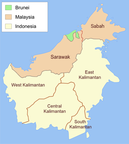
English: Administrative map of Borneo in English label. |
| Date | |
| Source | Own work, translate from File:Administrative map of Borneo (Indonesian).png |
| Author | Ranking Update |
| Permission (Reusing this file) |
I, the copyright holder of this work, hereby publish it under the following license: This file is licensed under the Creative Commons Attribution-Share Alike 3.0 Unported license.
|
.png)

|
This map image could be re-created using vector graphics as an SVG file. This has several advantages; see Commons:Media for cleanup for more information. If an SVG form of this image is available, please upload it and afterwards replace this template with
{{vector version available|new image name}}.
It is recommended to name the SVG file “Control of the island of Borneo.svg”—then the template Vector version available (or Vva) does not need the new image name parameter. |
File history
Click on a date/time to view the file as it appeared at that time.
| Date/Time | Thumbnail | Dimensions | User | Comment | |
|---|---|---|---|---|---|
| current | 10:02, 20 July 2021 | | 1,080 × 1,202 (207 KB) | Davidelit | Reverted to version as of 09:57, 20 July 2021 (UTC) |
| 10:01, 20 July 2021 |  | 1,080 × 1,202 (232 KB) | Davidelit | Reverted to version as of 17:28, 4 August 2017 (UTC) | |
| 09:57, 20 July 2021 |  | 1,080 × 1,202 (207 KB) | Davidelit | Provinces as during the Confrontation, i.e. no North Kalimantan | |
| 17:28, 4 August 2017 |  | 1,080 × 1,202 (232 KB) | Night Lantern | fixed font | |
| 20:01, 16 July 2017 |  | 1,200 × 1,335 (146 KB) | Maproom | Updated name of northernmost province | |
| 22:03, 1 August 2013 |  | 1,200 × 1,335 (207 KB) | Muffin Wizard | User created page with UploadWizard |
File usage
There are no pages that use this file.